staff and wire services
The first winter storm socked it to rural Nevada but left Wendover virtually unscathed Tuesday.
The storm that brought more than a foot of snow to the Sierra and record rainfall to Reno and Winnemucca on Monday dropped a record 3.6 inches of snow at Elko Airport with a chance of up to 8 inches in the mountains into Wednesday, the National Weather Service said.
A winter weather advisory remained in effect until 4 p.m. Wednesday in White Pine County along the Utah line. The heaviest snow was expected Tuesday night and Wednesday morning between Ely and Great Basin National Park near Baker — 2 to 6 inches in the valleys and as much as 1 to 2 feet in the mountains, the weather service said.
 Winds gusting in excess of 50 mph accompanied the storm that left 22 inches of snow at the Wildhorse Reservoir 25 miles south of Owyhee at the Idaho line, the service said Tuesday. Tuscarora had 18 inches of snow, Jarbidge 17 inches and Austin 12 inches.
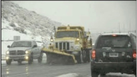
Six inches of snow fell in Carlin. School was canceled Tuesday, and most residents were without power for more than eight hours after trees fell on power lines in winds gusting in excess of 50 mph along Interstate 80 about 12 miles west of Elko. Several vehicles slid off I-80 west of Carlin before the Nevada Highway Patrol closed the westbound lanes across the 6,114-foot Emigrant Pass shortly after midnight until midday Tuesday.
Multiple accidents also were reported south of Elko in Spring Creek, where 4 inches of snow fell, the patrol said. There were reports throughout rural Elko County of tree limbs on cars, homes and roadways, but no immediate injuries or serious damage.
Isolated power outages were reported after heavy snow snapped five power poles in the Ruby Valley east of Elko, where the low temperature is forecast to dip to 12 degrees by Wednesday night.
 The 3.6 inches of snowfall in Elko Tuesday beat the old record of 2.4 inches for the date set in 1957, and the .39 inches of rainfall was .02 more than the previous record set in 1968, the service said.
Snow fell early Tuesday as far south as Mt. Charleston west of Las Vegas, where 2 inches was reported at the Lee Canyon ski area, elevation 9,200 feet. A 70-mph wind gust also was recorded near there at the Spring Mountain Youth Camp, elevation 8,380 feet. A winter weather advisory remained in effect for that area through 4 p.m. Wednesday.
The back end of the storm churned strong winds from north of Las Vegas into Lincoln County, where another winter advisory was in effect until 4 p.m. Wednesday above 5,500 feet, and in White Pine County, where a wind gust reached 58 mph at Baker.
While folks in Ely Elko and Carlin were digging out Wednesday Wendover escaped the blizzard hardly aware that it happened. The Nevada/Utah border town reported some rain Tuesday but other than that the tumult the storm cause just 30 miles west and 40 miles south was unnoticed except by drivers headed either to or from the affected areas.