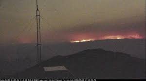
The Goose Creek FireThe Goose Creek Fire South East of Jackpot, strait line up North of Wendover border between Nevada and Utah, started Thursday July 26 at approx. 05:00 p.m., by lightning. Coordinates: 41.474 latitude, -114.066 longitude It is 25,000 Acres. Nevada Interagency Team 3 took over management of this fire at 6:00 pm on July 28, 2018. There is 166 personnel. The estimated containment date is Friday, August 3rd, approx. 6:00 p.m. At the latest update of 7/29/18, 12:10p.m.: 10% contained Projected Incident Activity: Continued spread to the south toward White Rock Peak and east towards Etna, Ut will continue through the evening and the majority of the night threatening the community. Poor RH recovery overnight will allow the fire to remain active most of the night. Fuels Involved: Timber (Grass and Understory) Brush (2 feet) Significant Events: Extreme, Running, Flanking, Group Torching Weather Concerns: Extreme heat and low RHs coupled with twice the average fine fuel loading are contributing to the high spread rates. |
China Jim Fire
There is 38 personnel. The estimated containment date is Tuesday July 31st, at approx. 11:00 p.m.
Weather Concerns: Extreme heat and low RHs coupled with twice the average fine fuel loading are contributing to high spread rates and extreme fire behavior.