
The Goshute Cave Fire in and outside the Goshute Canyon Wilderness, about 55 miles north of Ely, Nev., halfway between Wendover and Ely, near the Lages intersection between I93 and Alternate 93, grew overnight to approximately 15,000 acres.
Most of the increase was internal, except for the southeast flank that is backing into Carry Creek, about nine miles north of the Cherry Creek community. Firefighters are constructing a dozer line between Carry and Flat creeks that will tie-in with the already-established line along the fire’s eastern edge. Hand crews today made good progress securing a line from the northeast to the northwest flank and are working toward the south flank of the fire.
Fire and public safety is the top priority. No structures are threatened at this time. Area road and trail closures are in effect.
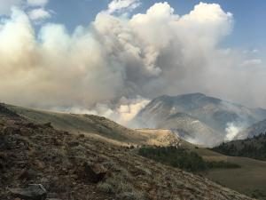
The lightning-ignited fire is burning in general Greater Sage grouse and critical mule deer winter and summer habitat. It is consuming white fir, mountain mahogany, limber pine, brush and grass.
Residents in northern White Pine County and motorists traveling U.S. Highway 93 can expect to see smoke from the fire, which was first reported at about 3 p.m., Monday, Aug. 13.
Smoke in Wendover and Wells are at high level.
As of Aug. 26th, 6:50 p.m.:
Coordinates: 40.063 latitude, -114.846 longitude
Significant Events: Active fire behavior with wind and terrain driven runs with short-range spotting, flanking and backing against the wind was observed for most of today’s operational shift with the most significant runs to the northeast within the perimeter and backing to the southeast. Winds were sustained at 20-25 mph with gusts up to 35 mph from the southwest, depending on the influence by terrain and slope.Fuels Involved: The primary carrier of the fire is White Fir, Limber Pine, Mountain Mahogany at the higher elevation. However as the fire has progressed more north, northwest, and northeast, pinion pine, juniper, sage and grass are the primary carrier of the fire, which as of this afternoon consumed approximately 4,000 acres of general and additional sage grouse habitat. Critical mule deer summer and winter range and cattle and sheep allotments have also been impacted.
Weather Concerns: Fire weather warning, continued southwest winds of 20-25 mph with gusts of 35 mph are forecast through 11 p.m., this evening. The forecast was pretty accurate during this operational shift. Wind gusts of 38-40 are observed. Single digit RH recordings.
Planned Actions: High in the Timber pockets where there is continuous fuel on the east, southeast, northeast. There is also a high potential for spread to the northwest in the pinion-juniper, sage and grass if winds increase and the fire gets established like it did yesterday and we are unable to get some of the perimeter checked. There is a small slop-over on the ridge to the west that can also cause problems if unchecked. The Type 1 helicopter is very effective in keeping this slop-over in check, however high winds continue to slow progress in securing the slop-over.