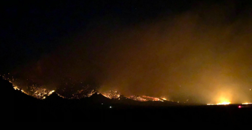
The Goshute Cave Fire in and outside the Goshute Canyon Wilderness, about 55 miles north of Ely, Nev., halfway between Wendover and Ely, near the Lages intersection between I93 and Alternate 93, is now an estimated 17,749 acres, as per Aug. 28th, 2018, at around 8:00 pm.
Except for a portion of the west flank that is backing into the head of McDermid Creek in terrain inaccessible to firefighters, there has been no perimeter growth. Though McDermid Creek is well within the confinement area, firefighters today were constructing a contingency line from McDermid Creek to Calf Canyon. Helicopters worked the southern flank of the fire.
Firefighter and public safety is the top priority. At this time, there is no threat to structures. Area road and trail closures are in effect.
The lightning-ignited fire is burning in general Greater Sage grouse and critical mule deer winter and summer habitat. It is consuming white fir, mountain mahogany, limber pine, brush and grass.
Residents in northern White Pine County and motorists traveling U.S. Highway 93 can expect to see smoke from the fire, which was first reported at about 3 p.m., Monday, Aug. 13.
Estimated Containment Date: Monday October 1st, 2018 at approx. 8:00 pm.
Most of the increase was internal, except for the southeast flank that is backing into Carry Creek, about nine miles north of the Cherry Creek community. Firefighters are constructing a dozer line between Carry and Flat creeks that will tie-in with the already-established line along the fire’s eastern edge. Hand crews today made good progress securing a line from the northeast to the northwest flank and are working toward the south flank of the fire.
Fuels Involved: The primary carrier of the fire is White Fir, Limber Pine, Mountain Mahogany at the higher elevation. However as the fire has progressed more north, northwest, and northeast Pinyon, Juniper , Sage and grass are the primary carrier of the fire, which as of this afternoon consumed approx. 4000 acres of general and additional Sage Grouse Habitat. Critical deer summer and winter range along with sheep and cattle allotments have also been impacted.
Significant Events: Moderate fire behavior with short duration runs upslope along with flanking and backing downslope against the wind was observed on the western flank at the head of McDermid Creek. Interior group torching continues on the east. No perimeter growth was shown on any other areas of the fire. Crews made good progress securing direct line and widening line from the Southeast to the Northwest.
Outlook:
Planned Actions: Identify management action points for future tactical implementation, point protection on identified sites if safe to do so. Monitor from strategic vantage points and provide intel. Patrol the fire edge on the east, north, northeast, and northwest with Engines. Depending on fire activity and clean black, try and engage the Type 2 IA crews on the western flank and go direct with air support. continue building contingency line with dozers, a mower and hand crews from McDermid to the north in Calf Canyon and into Calf Canyon working west. Finish building defensible space at the mouth of McDermid Canyon where structures are located. Bucket wok will continue in Carry Canyon unless they are able to get into McDermid Creek to help support the crews.
Projected Incident Activity: High in the interior timber pockets where there is continuous fuel on the east, north, northwest, northeast. Low to moderate on the South and Southwest. There is a high potential for spread down canyon in McDermid Canyon in the heavy timber stringers. 1,000 hour fuel moistures continue to show at record lows. Winds are predicted to increase over the next 12-24 hours.
Current Weather:
Weather Concerns: RH’s will be lower tonight than last, with warmer temperatures and fairly light winds. Wednesday, temperatures will climb back above normal levels with winds increasing out of the west-southwest. Tomorrow’s temperatures: 80-90 degrees F, RH 9-14%
Previous Report was published on this website Aug. 27th, 2018( from a 8/26/18 update):
Fire and public safety is the top priority. No structures are threatened at this time. Area road and trail closures are in effect.
The lightning-ignited fire is burning in general Greater Sage grouse and critical mule deer winter and summer habitat. It is consuming white fir, mountain mahogany, limber pine, brush and grass.
Residents in northern White Pine County and motorists traveling U.S. Highway 93 can expect to see smoke from the fire, which was first reported at about 3 p.m., Monday, Aug. 13.
Smoke in Wendover and Wells are at high level.
As of Aug. 26th, 6:50 p.m.:
Coordinates: 40.063 latitude, -114.846 longitude
Significant Events: Active fire behavior with wind and terrain driven runs with short-range spotting, flanking and backing against the wind was observed for most of today’s operational shift with the most significant runs to the northeast within the perimeter and backing to the southeast. Winds were sustained at 20-25 mph with gusts up to 35 mph from the southwest, depending on the influence by terrain and slope.Fuels Involved: The primary carrier of the fire is White Fir, Limber Pine, Mountain Mahogany at the higher elevation. However as the fire has progressed more north, northwest, and northeast, pinion pine, juniper, sage and grass are the primary carrier of the fire, which as of this afternoon consumed approximately 4,000 acres of general and additional sage grouse habitat. Critical mule deer summer and winter range and cattle and sheep allotments have also been impacted.
Weather Concerns: Fire weather warning, continued southwest winds of 20-25 mph with gusts of 35 mph are forecast through 11 p.m., this evening. The forecast was pretty accurate during this operational shift. Wind gusts of 38-40 are observed. Single digit RH recordings.
Planned Actions: High in the Timber pockets where there is continuous fuel on the east, southeast, northeast. There is also a high potential for spread to the northwest in the pinion-juniper, sage and grass if winds increase and the fire gets established like it did yesterday and we are unable to get some of the perimeter checked. There is a small slop-over on the ridge to the west that can also cause problems if unchecked. The Type 1 helicopter is very effective in keeping this slop-over in check, however high winds continue to slow progress in securing the slop-over.