
Sugarloaf and South Fork Campgrounds are both now open.
Closure area expected to remain as is until area receives significant rain or snow. Hunters may call the Colorado Parks and Wildlife office for hunting information at (970) 725-6200.
- Darling Creek Trailhead, Trail and surrounding area
- Ute Peak and Ute Pass Trailhead and Trail
- Western portion of Byers Peak Wilderness
All roads in the area are open, including FSR 138.
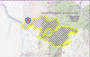
Another change in the weather is helping firefighters make progress on the South Sugarloaf Fire, which expanded by 700,000 acres over the weekend and prompted an expanded voluntary evacuation order and closure of the entire Mountain City and Jarbidge ranger districts on the Humboldt National Forest.
“Night shift firefighters were busy last night as the fire became very active in the Gold Creek Administrative site and Big Bend Creek area,” fire managers reported Monday morning. “Crews were able to provide structure protection around homes and a Forest Service administrative site. None of the homes burned but one Forest Service outbuilding was destroyed.
The fire did not burn as intensely in other locations as it had on previous nights due to a cold front which brought cooler temperatures and higher humidity. Crews were able to secure containment lines in these areas.
There was no updated fire size Monday morning because it was too cloudy for an infrared overflight to get accurate information Sunday night. At last report the fire had burned 200,692 acres and was 53 percent contained.
A voluntary evacuation was ordered Sunday for the area east of Wild Horse Reservoir to Bear Creek Road, then north to the Nevada-Idaho border, including the community of Jarbidge, then west along the border to the Meadow Creek Road, and back south to Wildhorse Reservoir. Voluntary evacuations remain in effect for residences along Maggie Summit Road, Mountain City, Wildhorse Estates, Wildhorse Recreation Area, and the Gold Creek Area.
“Due extreme fire behavior and the continued growth of the South Sugarloaf Fire, the Humboldt-Toiyabe National Forest closed 754,448 acres on the Mountain City-Ruby Mountains-Jarbidge Ranger District,” the Forest Service reported Sunday evening. “The new area closure, which goes into effect today, closes additional areas to the public that are not safe to enter due to the active fire behavior and fire suppression activities.”
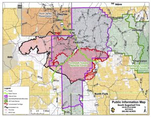 All portions of Mountain City and Jarbidge ranger districts are closed for public safety. This includes all campgrounds, roads, trailheads, and trails are closed west of Forest Road 753 (O’Neil Basin area), north of U.S. Interstate 80, and east of Elko County Road 785/Nevada State Route 226, and south of the Shoshone-Paiute Tribes of the Duck Valley Reservation boundary line.
Campgrounds closed are Jack Creek, Big Bend, Wildhorse Crossing, Pine Creek, and Sawmill Campgrounds. This closure also effects Nevada Department of Wildlife’s hunting areas 061, 062, 071, 072.
“This closure will remain in effect until the Forest Service determines the area is again safe for the public. People who are found guilty of violating this closure order could receive a maximum fine of $5,000 or six months in jail or both,” the Forest Service stated.
On Saturday the fire jumped Nevada State Route 225 between the Wildhorse Reservoir Dam and Maggie Creek Road, then burned east toward the Haystack and Rough Mountain areas.
Fire managers were expected to “make some good headway” Monday due to the lower temperatures, higher humidity, and calmer winds. Fire crews will continue with their full suppression efforts, focusing primarily on the most active edge of the fire along the northern and eastern edges. Firefighters are working around the clock with day and night shifts to control and contain the fire.